
 n
nDigital Agriculture in India: Bridging the Phygital Divide
Digital agriculture offers a revolutionary template to de-risk Indian farming, but its success hinges on bridging the "phygital" (Physical + Digital) divide. To ensure this data-driven transition empowers rather than excludes smallholders, India must look beyond pure technology and invest heavily in rural digital literacy, inclusive legal frameworks for tenant farmers, and decentralised community-led infrastructure.
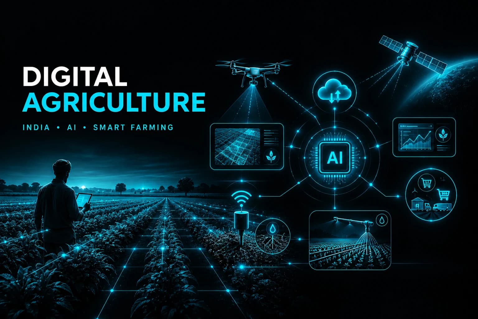
Digital Agriculture
Digital Agriculture is the integration of Information and Communication Technologies (ICT), data science, and advanced hardware into the entire agricultural value chain.
While traditional farming relies on historical calendars and manual labor, digital agriculture shifts the entire food system—from "farm to fork"—into a data-driven, hyper-connected, and automated ecosystem.
It breaks the technology down into 3 distinct, chronological operational steps:
Data Capture (Input Layer): Focuses on how data is harvested using hardware like satellite multi-spectral imaging, agricultural drone sensors, and in-situ soil moisture probes.
Intelligence (Analytical Layer): Represents the cloud-computing and AI models that process that raw field data into automated mobile advisories and predictive planting patterns.
Action & Logistics (Execution Layer): Focuses on how those data insights are physically executed via autonomous machinery, blockchain traceability tags, and direct B2B digital marketplaces.
Precision Agriculture vs Digital Agriculture: Precision Agriculture is focused strictly on the field. It uses tools like GPS tractor guidance, variable-rate fertilizer applicators, and soil moisture sensors to ensure inputs are applied in exact quantities to specific zones.
Digital agriculture includes precision farming but expands across the entire value chain. It encompasses upstream seed R&D, on-farm cultivation, downstream logistics, smart warehousing, e-commerce, and blockchain-enabled traceability.
What are the Key Benefits of Digital Agriculture for Indian Farmers?
Universal Identity and Frictionless Credit via AgriStack: The creation of Digital Public Infrastructure (DPI) in agriculture removes the traditional, predatory middlemen who exploit smallholders lacking formal documentation.
By establishing a single source of truth linking data across a Farmers Registry, Geo-Referenced Village Maps, and a Crop Sown Registry, farmers can access institutional credit instantly without cumbersome physical paperwork.
According to recent data, more than 8.48 crore Farmer IDs have been generated. States like Maharashtra have leveraged this framework to seamlessly process disaster relief and credit access, ensuring direct benefit transfers skip local leakage points.
AI-Driven Hyper-Local Precision Farming: Artificial Intelligence (AI) platforms combine satellite datasets, internet-of-things (IoT) field sensors, and weather parameters to push tailored, site-specific advisories to a farmer's phone, pinpointing what to sow, when to irrigate, and exactly how much input to use.
In Tamil Nadu, farmers adopting indigenous, solar-powered AI precision farming systems successfully doubled coconut yields while saving over 400,000 cubic meters of water. This showcases how localised AI reduces waste and boosts physical productivity.
Automated Pest Mitigation via National Systems: Digital image recognition allows farmers to photograph an infected crop on their smartphones and instantly receive an automated botanical diagnosis along with target mitigation guidelines.
The centrally deployed National Pest Surveillance System (NPSS) uses machine learning models to support 65+ crops and over 400 pest types. Operating through a network of over 10,000 rural extension workers, it prevents catastrophic crop failure through real-time localised warnings.
Scientific Input Optimisation, Mechanisation and Price Discovery
Scientific Input Optimisation and Soil Preservation: Integrating digital registries with automated soil analysis helps farmers apply nutrients using a precise variable-rate application methodology, ensuring chemical combinations match the absolute missing nutrient gradient of that specific plot.
The Ministry of Agriculture & Farmers Welfare’s Soil Fertility Maps provide detailed spatial information about the nutrient composition and health of the soil. It helps farmers in the application of fertilisers and soil amendments judiciously, reducing the risk of overuse or underuse.
Democratisation of Mechanisation via Namo Drone Didi: Digital services support Custom Hiring Centres (CHCs) and automated drone fleets. This allows smallholders to lease state-of-the-art agricultural equipment via mobile applications on an on-demand, pay-per-use basis.
Under the Namo Drone Didi Scheme, the government aims to provide drones to 15000 selected Women SHGs during the period from 2024-25 to 2025-2026 for providing rental services to farmers for agricultural purposes. This initiative brings precise, automated liquid spraying to smallholder fields while establishing a secondary source of rural service income.
Transparent Price Discovery through e-Marketplaces: Digital trading networks open local crop lots to inter-mandi and electronic pan-India bidding, providing accurate price discovery and breaking regional cartelization.
The integration of the e-NAM (Electronic National Agriculture Market) platform, along with tools like Kisan Saarthi, allows smallholders to check terminal prices across multiple states before releasing their stocks. This ensures they capture a higher share of the consumer rupee.
Quality Control, Traceability and Disaster Assessment
Quality Control and National Seed Grid Traceability: Digital tracking platforms introduce cryptographic transparency from the initial seed production stage down to the retail dealer's counter.
The SATHI (Seed Authenticity Traceability & Holistic Inventory) portal establishes a unified National Seed Grid. By scanning QR codes on seed packaging, a farmer can instantly verify quality certifications and seed origins, protecting their capital investment before sowing.
Accurate Disaster Assessment and Swift Insurance Payouts: Merging Digital Crop Surveys with satellite remote sensing allows insurance networks to run automated, macro-level assessments of weather-induced damages, bypassing bureaucratic delays.
E.g., Chhattisgarh has institutionalised Farmer ID and Digital Crop Survey for MSP-based paddy procurement, covering over 32 lakh farmers in a single season.
Similarly, Maharashtra utilised AgriStack analytics to rapidly clear and transfer over ₹14,000 crore for Kharif crop losses to 89 lakh farmers, proving that digital infrastructure builds strong financial resilience against climate risks.
What are the Key Government Initiatives to Promote Digital Agriculture?
Digital Agriculture Mission (DAM): Approved with a total outlay of ₹2,817 crore, DAM serves as the comprehensive national umbrella framework designed to drive innovative, farmer-centric tech solutions. It directly integrates India's primary digital public grids to ensure timely, data-driven service delivery. The scheme is built on two foundational pillars:
AgriStack: This is the foundational identity and transactional core managed under DAM. It is built on 3 central registries to digitize field operations:
Farmers’ Registry (Kisan ID): Generates an 11-digit unique digital identity for landholding farmers. It serves as a single credential to seamlessly authenticate and disburse benefits under PM-KISAN, Kisan Credit Cards (KCC), and Minimum Support Price (MSP) procurements.
Geo-Referenced Village Maps: Cadastral maps that link physical field boundaries with precise geographic coordinates for parcel-level transparency.
Crop Sown Registry: Drives the Digital Crop Survey (DCS), a mobile-based seasonal logging system that has already surveyed over 28.5 crore crop plots across hundreds of districts to provide ground-truth planting data.
Krishi Decision Support, Soil Mapping and AI Advisory Frameworks
Krishi Decision Support System (Krishi-DSS): This is the geospatial and analytical engine under DAM. It acts as a single source of truth by layering satellite imagery, weather models, reservoir metrics, and groundwater trends onto a unified map.
Soil Profile Mapping: Under the mission, detailed soil profile maps on a 1:10,000 scale for approximately 142 million hectares of agricultural land have been envisaged, with 29 million hectares of soil profile inventory already being mapped.
Advanced AI & Multilingual Advisory Frameworks:
Bharat-VISTAAR: It is an AI-powered helpdesk providing instant agricultural answers in regional languages. Currently available in Hindi and English, it is expanding to support 11 languages (English, Hindi, and 9 regional languages).
Agri Param: It is a domain-specific agricultural large language model running across 22 Indian languages. It translates complex data into spoken, hyper-local advice.
Kisan e-Mitra: An AI-powered, voice-based chatbot developed specifically to answer queries regarding agricultural schemes (handling an average of 8,000+ daily queries in 11 regional languages).
Production, Insurance and Market Delivery Grids
Production, Insurance, and Market Delivery Grids:
Digital General Crop Estimation Survey (DGCES): It standardizes and digitizes traditional Crop-Cutting Experiments (CCEs) via mobile geotagging and machine learning algorithms, providing reliable yield data for fast insurance adjustments.
National Agriculture Market (e-NAM): A pan-India electronic trading portal that networks physical APMC mandis (over 1,600 mandis integrated across states) to create a unified national market. It enables digital price discovery, remote bidding, and transparent online payment settlements.
Sub-Mission on Agricultural Mechanization (SMAM): This initiative provides targeted fiscal subsidies to scale up precision machinery through FPO-led Custom Hiring Centers (CHCs), making digital hardware affordable via fractional, pay-per-use rental models.
What are the Barriers to the Widespread Adoption of Digital Agriculture in India?
Highly Fragmented Farmland Holdings: According to the Agriculture Census 2015-16, 86% of Indian farmers are small and marginal, operating on an average landholding size of just 1.08 hectares.
These minuscule, physically separated plots make the deployment of heavy capital equipment like high-end drones or GPS-guided tractors operationally inefficient and logistically impractical.
Systemic Exclusion of Tenant Farmers and Sharecroppers: Digital agricultural ecosystems and state-backed welfare systems use legal land titles as the primary identifier to assign a unique Farmer ID (FID).
Because tenant farmers and sharecroppers lack formal lease agreements or land registration documents, digital platforms cannot register them, effectively excluding them from digital credit access, subsidized agritech inputs, and automated insurance payouts.
According to NSO's 2018–19 survey, tenant holdings, land farmed by those who don't own it, increased from 9.9% (2002-03) to 17.3% (2018-19) in 16 years. In Andhra Pradesh, that figure is as high as 42%. Relying exclusively on land-title-centric digital identification risks worsening rural economic inequities.
High Capital Intensity and Extended ROI Cycles: Hardware like multi-spectral drone cameras, IoT-based automated soil sensors, and localized micro-weather stations carry prohibitive initial capital costs that the average resource-poor Indian farmer cannot absorb. Furthermore, because agricultural innovation cycles are dependent on seasonal weather patterns, the financial Return on Investment (ROI) takes several years to materialize.
Private venture capital and agritech startup financing remain highly concentrated in downstream e-marketplaces rather than upstream hardware deep-tech. This uneven capital distribution restricts the availability of low-cost, pay-per-use digital tools for smallholders.
Infrastructure, Data and Digital Literacy Barriers
The "Phygital" Divide and Infrastructure Deficits: Real-time precision farming relies on the continuous transmission of heavy data payloads from IoT devices to cloud servers. Many remote farming belts suffer from erratic power grids and unstable rural internet connectivity, rendering real-time edge computing and live automated advisories ineffective during critical weather crises.
Despite the rise in mobile connectivity, only 8% of rural households have broadband connections, forcing reliance on mobile data. Furthermore, regional disparity is stark: while Kerala’s rural tele-density (number of mobile phones per 100 rural population) exceeds 100, tele-density remains below 50 in Madhya Pradesh, Bihar, Uttar Pradesh, Jharkhand, and Chhattisgarh.
Institutional Data Silos and Lack of Interoperability: India’s agricultural datasets remain heavily fragmented across institutional silos governed by different central and state entities. A farmer’s weather data is primarily held by the IMD, soil profile information resides with state departments and the Soil and Land Use Survey of India (SLUSI), crop insurance metrics are captured within the PMFBY ecosystem, and market transaction data is largely confined to standalone APMC mandi systems.
A recent NITI Aayog roadmap on frontier technologies in agriculture underscores that non-standardised formats and incomplete data federation still compromise the reliability and accuracy of AI-driven predictive modelling for crop yields, risk assessment, and advisory services.
Severe Digital Literacy and Localised Language Barriers: A deep digital literacy deficit persists among older, traditional farming communities. Furthermore, most advanced agritech applications and diagnostic dashboards are initially developed in English or standard Hindi.
Data from the Comprehensive Modular Survey on Telecom (CMST) 2025 by the NSO reveals that while 90% of rural households have at least one member capable of basic internet usage, 39% of rural adults are functionally digitally illiterate, meaning they cannot use the internet for informational purposes (knowledge gain, digital payments, or online transactions).
Smartphone ownership stands at only 44% for Scheduled Tribes and 47% for Scheduled Castes, compared to 57% for other castes.
Data Privacy Risks and Sovereign Federal Friction
Data Privacy Risks and Sovereign Federal Friction: Under the AgriStack model, individual state governments collect and maintain granular field-level records, but the Union Government caches and aggregates the data into a centralised national repository. This creates major centre-state federal friction regarding data ownership.
Simultaneously, sharing sensitive farmer demographics with private agritech companies via pilot MoUs increases data privacy risks and corporate exploitation concerns in the absence of stringent, localised rural data enforcement frameworks.
Legal and economic researchers warn that without robust consent-brokerage architectures, opening up farmer datasets to commercial entities could lead to predatory pricing or algorithmic profiling of vulnerable rural populations.
How to Accelerate the Adoption of Digital Agriculture in India?
Build Decentralised API Gateways over Local Land Registries: State governments should launch localised API (Application Programming Interface) proxy gateways that securely connect regional land registries directly to local private agritech systems.
Instead of waiting for top-down national database updates, this local integration allows private developers to instantly verify plot boundaries and tenancy agreements, unlocking immediate access to precise, automated crop advisories for nearby smallholders.
Transition KVKs into Agri-Tech Demonstration Hubs: Upgrade the network of Krishi Vigyan Kendras (KVKs) into active digital experience centres, operated through public-private partnerships.
By equipping these hubs with functional precision tools—such as variable-rate fertiliser applicators, automated soil sensors, and drone flight simulators—local farmers can interact with the technology firsthand. This continuous, hands-on demonstration builds the necessary trust to drive adoption.
Deploy Low-Power Wide-Area Networks (LPWAN) via BharatNet: Leverage existing BharatNet fibre infrastructure to deploy regional, open-access LoRaWAN (Long Range Wide Area Network) gateways across rural panchayats.
Providing this low-cost, low-power connectivity framework allows farmers to deploy automated soil moisture probes and smart irrigation valves that run for years on standard batteries, eliminating ongoing cellular data costs.
Implement Reverse-Incentive Subsidies Linked to IoT Data: Restructure equipment subsidies into a performance-based "Data-for-Subsidy" model.
Farmers who share verified operational data from their connected tools—such as proof of reduced water usage via smart irrigation or lower chemical input from precision sprayers—receive direct cash back via Direct Benefit Transfer (DBT).
This approach directly offsets their initial technology investment by rewarding resource conservation.
Community Data Cooperatives, Digital Krishi Entrepreneurs and Conclusion
Establish FPO-Led Data-Sharing Cooperatives: Organize Farmer Producer Organisations (FPOs) into Data-Sharing Cooperatives that manage collective agricultural data as a shared asset.
By gathering and anonymising local soil, yield, and pest information, FPOs can securely license this data to agritech firms, seed developers, and research institutions. The revenue generated goes right back to the community, creating a new income stream that funds further technology adoption.
Recruit and Train a Local Network of "Digital Krishi Entrepreneurs": Launch a dedicated vocational program to train rural youth as certified "Digital Krishi Entrepreneurs".
Equipped with shared diagnostic toolkits—such as handheld soil scanners and portable crop-imaging tools—these young professionals function as local tech support providers.
They earn an income by offering on-demand diagnostic and precision spraying services to nearby farms, establishing a self-sustaining support network right within the community.
Launch De-Risked Agri-Fintech Sandboxes for Alternative Credit: Establish regulatory sandboxes that enable banking institutions to implement alternative data underwriting models.
By pulling verifiable digital footprint data—such as satellite-monitored historical crop performance, historical marketplace transactions, and connected IoT sensor logs—fintech platforms can accurately score a farmer's creditworthiness. This opens up automated, low-interest micro-loans for the unbanked agricultural workforce.
Conclusion: India's digital agriculture holds transformative potential but risks excluding smallholders due to infrastructure deficits, land-tenure biases, and low digital literacy. Bridging this phygital divide necessitates decentralized governance, localized capacity building, and alternative credit models to ensure inclusive, farmer-centric technological progress.
What is the core objective of Digital Agriculture in India? To integrate ICT, data science, and AI across the entire value chain to boost productivity, ensure transparent price discovery, and provide farmers with timely, personalized advisories and credit.
What is the 'phygital divide' mentioned in the context of Indian agriculture? The gap between digital initiatives and physical infrastructure, characterized by unreliable internet connectivity (only 8% rural broadband) and erratic power grids, hindering real-time data transmission.
What role does the SATHI portal play in the National Seed Grid? SATHI introduces cryptographic transparency by allowing farmers to scan QR codes on packaging to instantly verify quality certifications and seed origins, protecting their capital from counterfeit inputs.